01105 is zip code located in Springfield, Massachusetts. The population is 12,664, making 01105 the 6th largest zipcode in Springfield.
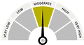
There are 7 public schools in 01105 with an average Homefacts rating of D. The total crime rate for Springfield is high , and there are 93 registered sex offenders residing in the zip code 01105. Unemployment in 01105 is high.
Zip codes within Springfield include 01101, 01102 and 01103.