Westfield, Massachusetts

Population 41,301

Westfield is located in Hampden County, MA. The population is 41,301, making Westfield the 3rd largest city in Hampden County.

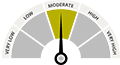
There are 0 public schools in Westfield with an average Homefacts rating of C+. The total crime rate for Westfield is moderate , and there are 17 registered sex offenders residing in the city. Unemployment in Westfield is moderate and the median home sales price is $0. Detailed and up-to-date Westfield property reports are available for any property address.

Cities near Westfield include Russell, West Springfield and Southwick.

Westfield Neighborhood Report

Schools

School Rating is Above average
  • No High School Diploma: 7.8%
  • High School Graduate or Higher: 59.9%
  • Bachelor's Degree or Higher: 32.4%

Crime Rate

53.7% Lower than national avg.
  • Auto theft: 53
  • Violent Crimes: 200
  • Robbery: 17
  • Burglary: 125
  • Property Crime: 959
  • Larceny Theft: 781

Registered Offenders

69.61% Lower than national avg.
  • 17 offenders in Westfield
  • 4.12 offenders/10,000 residents

Environmental Hazards

284 Found nearby
  • Brownfields: 0
  • Registered Polluters: 2
  • Superfunds: 0
  • Tanks & Spills: 282

Unemployment

Moderate 4.0%
  • Massachusetts unemployment average: 3.5%
  • National unemployment average: 3.7%

Property Values

Median Property Value $0

Schools view all

0 Public Schools view public schools

  • Top Rated Public Schools Rating
  • We're sorry! No schools found in our database
Summary
There are 0 K-12 public schools in Westfield, MA and 0 private schools. Homefacts rates Westfield's schools as Above average, with an overall C+ rating.
  • School District Rating
  • We're sorry! No Schools District found in our database.

1 Colleges & Universities view all colleges & universities

View All School Information

Crime view details

17 Registered Offenders search the registered offender database

View All Registered Offenders

Crime Index view report

*100 is national avg. Greater than 100 means higher crime, lower means less crime.
  • Total Crime Index
  • Violent Crime Index
  • Property Crime Index

0 Former Drug Labs view all

  • Good news! No Drug lab found in Westfield, MA

Property Reports view all

26 Building Permits View All

  •  
  • In 2014, the city of Westfield, MA issued 26 building permits. All permits issued were for Single Family Homes. Of those 26 permits, 22 were issued for single family homes and 4 were issued for multi-family homes.
  • In 2013, the city of Westfield, MA issued 29 building permits. All permits issued were for Single Family Homes. Of those 29 permits, 25 were issued for single family homes and 4 were issued for multi-family homes.
All Housing Single Family Housing Multi-Family Housing

Building Permits By Year

Fair Market Rents

**Displaying data from Westfield, MA
  • Property Type Rent
  • Studio: $727
  • 1 Bedroom: $874
  • 2 Bedrooms: $1,094
  • 3 Bedrooms: $1,353
  • 4 Bedrooms: $1,623

View All Home Reports

Environmental Hazards

284 Environmental Hazards

  • Brownfields
    in Westfield, MA
    view all
  • Registered Polluters
    in Westfield, MA
    view all
  • Superfunds
    in Westfield, MA
    view all
  • Tanks & Spills
    in Westfield, MA
    view all

Health Hazards

  • Air Quality HEALTHY (340/354)
    Westfield, MA has 96.05% good air quality.
    view all
  • Radon ZONE 2 COUNTY
    Westfield, MA is a yellow zone.
    view all
  • UV Index MODERATE 3.74 Average
    Westfield, MA is a moderate risk area for ultra-violet rays.
    view all

Weather

  • We're sorry! No Weather statistics found in our database.

Average Monthly Temperature

  • January 25°
  • February 28.83°
  • March 38.6°
  • April 50.02°
  • May 60.05°
  • June 67.7°
  • July 74.28°
  • August 71.1°
  • September 64.58°
  • October 52.32°
  • November 41.27°
  • December 30.93°

View More About Environmental Hazards

Natural Disasters

Probability of Natural Disasters for Westfield, MA

Earthquakes
Westfield, MA has a low risk of earthquakes.
Hurricanes
Westfield, MA has no risk of hurricanes.
Hail
Westfield, MA has a moderate risk of hail storms.
Tornadoes
Westfield, MA has a low risk of tornadoes.

Demographics view details

Median Household Income

Median Household Income in Westfield, MA: $62,969

Unemployment

Unemployment in Westfield is 4.0%. It is higher than the state and national averages, 3.5% and 3.7% respectively

Workforce Breakdown

Blue Collar - 39.13%
White Collar - 60.87%

Politics

State Representatives

  • Gov. Charlie Baker
  • Sen. Edward J. Markey
  • Sen. Elizabeth Warren

City Representatives

  • Richard E. Neal

Neighborhood Info

0 Airports view all

Nearest Major Airports

13 FCC Towers view all

0 Fire Stations view all

  • No fire stations found in Westfield, MA

0 Hospitals view all

  • No hospitals found in Westfield, MA

0 Libraries view all

  • No library found in Westfield, MA

0 Retirement Homes view all

  • No retirement homes found in Westfield, MA
Thank you for visiting the city of Westfield, MA.